


Le levassaix

Danielba
User GUIDE

Length
12 km

Max alt
1698 m

Uphill gradient
364 m
Km-Effort
16.8 km

Min alt
1402 m

Downhill gradient
359 m
Boucle
Yes
Creation date :
2023-03-14 13:57:21.222
Updated on :
2023-03-14 17:19:44.298
3h21
Difficulty : Difficult

FREE GPS app for hiking
 SityTrail
IGN / Geographical institutes
SityTrail Plus
The world is yours!
About
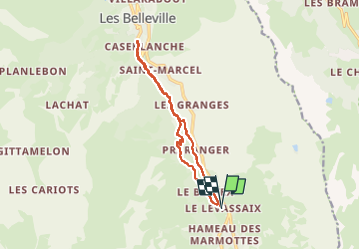
Trail Walking of 12 km to be discovered at Auvergne-Rhône-Alpes, Savoy, Les Belleville. This trail is proposed by Danielba .
Positioning
Country:
France
Region :
Auvergne-Rhône-Alpes
Department/Province :
Savoy
Municipality :
Les Belleville
Location:
Saint-Martin-de-Belleville
Start:(Dec)
Start:(UTM)
306683 ; 5023391 (32T) N.
Comments